Climate Displacement in India: The Sundarbans, Rising Floods and the Families Who Have Already Moved
India recorded 5.4 million disaster displacements in 2024, the highest in 12 years. How the Sundarbans, Assam and the Odisha coast show the problem, and which fixes have worked.
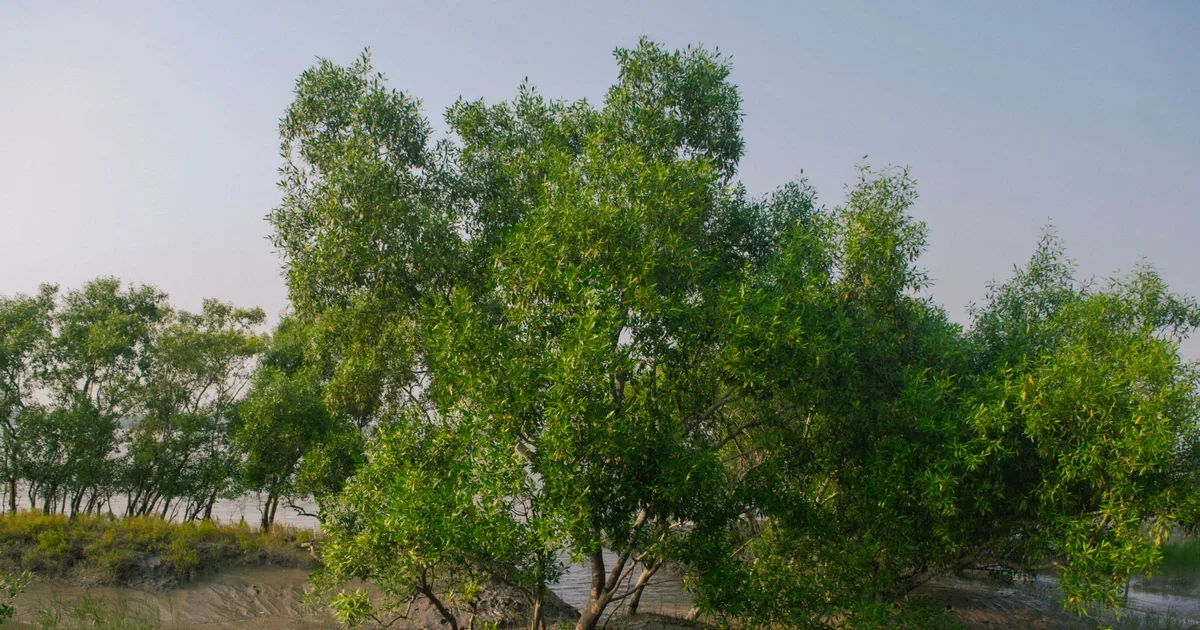
Mangroves in the Sundarbans delta. Photo by Biplab Sau on Pexels.
In this story
How many people does climate displace in India?
Every year, floods and cyclones push millions of people out of their homes in India for days, weeks or for good. The Internal Displacement Monitoring Centre (IDMC), a Geneva-based body that counts displacement worldwide, recorded 5.4 million disaster displacements in India in 2024, the highest figure in 12 years. Two-thirds were caused by floods. Assam alone accounted for 2.5 million movements, nearly half the national total, after its most intense floods in over a decade. Tripura’s worst monsoon in more than 40 years set off landslides in more than 2,000 places and triggered 315,000 displacements, according to the IDMC Global Report on Internal Displacement 2025.
A caution on the word “displacement” is needed. IDMC counts movements, not people, so one family forced out twice in a year counts twice. Most of these movements are short: people move to a relief camp, a relative’s house or higher ground and return when the water goes down. Only some end in permanent loss of home and land. In the Sundarbans, in the Brahmaputra’s river islands and on parts of the Odisha coast, the land itself is disappearing, and moving is no longer temporary.
This article looks at the numbers, the places where the loss is clearest, and what is working: mangrove restoration, early warning and shelters, planned relocation and stronger housing. It also says where each approach has failed, because the families affected deserve an honest account.
What does the IDMC data show?
Measure (2024) | Figure | Notes |
|---|---|---|
Disaster displacements in India | 5.4 million | Highest in 12 years |
Share caused by floods | About two-thirds | Wetter-than-average monsoon season |
Assam flood displacements | 2.5 million | Dhubri district alone: 560,000 |
Tripura landslide displacements | 315,000 | Mid-August 2024 rains |
Assam people still displaced at year-end | Nearly 50,000 | Most others returned as water receded |
IDMC names climate change, deforestation, erosion and poor maintenance of dams and embankments as main drivers of risk. On the Brahmaputra, it reports that of more than 400 embankments built along the river and its tributaries since the 1950s, over half have outlived their intended lifespan, and a lack of money for repair means a growing number are breached. Two lessons follow. First, climate is only one cause: ageing infrastructure and deforestation turn heavy rain into displacement. Second, the same people are hit again and again, which erodes the savings and coping methods they would need to recover.
How fast is India’s coast eroding?
The National Centre for Coastal Research (NCCR), part of the Ministry of Earth Sciences, mapped the whole Indian coastline from satellite images for 1990 to 2018. In a reply to the Lok Sabha on 10 August 2021, the government reported that about 32% of the 6,631 km coast had eroded, 27% had gained land and the rest was stable, as reported by Down To Earth. Later official statements round the eroding share to 33.6%.
State or UT | Coast eroded, 1990-2018 | Coast gained |
|---|---|---|
West Bengal | 60% | 25% |
Puducherry | 56% | 8% |
Kerala | 41% | 21% |
Tamil Nadu | 41% | 22% |
Odisha | 26% | 51% |
West Bengal, home to the Indian Sundarbans, had the highest share of eroding shoreline. Odisha lost land in places and gained it in others, which hides local damage. Kendrapara district in Odisha, for example, had 36% of its 136 km coastline eroded between 1990 and 2018, reported by the Eco-Business investigation citing a government release.
What is happening in the Sundarbans?
The Sundarbans is the delta where the Ganga, Brahmaputra and Meghna reach the Bay of Bengal, shared between India and Bangladesh. On the Indian side, 54 of the 102 islands are inhabited, according to the Sahapedia overview, and estimates of the population range from about 4.5 million to 4.6 million. Many villages sit only 1.5 to 3 metres above average sea level, and spring tides can reach 5 to 6 metres.
The same overview reports that the Sundarbans has lost more than 400 square kilometres of land over 100 years. Lohachara and Suparibhanga islands have gone from the maps. Ghoramara island shrank from 8.51 to 4.43 square kilometres, and its population fell from about 40,000 at one time to around 5,000 in the 2011 census. Figures vary by source and year, so these are best read as a direction, not an exact tally.
Why is the delta so exposed?
Three forces combine. The sea is rising, the land is sinking, and the mud embankments that protect the islands are weak. Kalyan Rudra, then chairman of the West Bengal Pollution Control Board, was quoted by Sahapedia saying coastal land in the delta is subsiding at about 2.9 mm a year on top of the sea-level rise. More than 90% of the embankments are still made of soft alluvial clay, and concrete ones are missing or in poor condition in many stretches, partly because land acquisition met local resistance.
Storms then do the damage. Sahapedia reports that Cyclone Aila in 2009 collapsed embankments in more than 100 places. Amphan in May 2020 had recorded winds of about 185 km/h, the highest on record in the state, according to the same source. When an embankment breaks, salt water floods fields, and farmland can be unusable for years. Families then borrow, migrate for work or both.
What does it mean for a family?
Akhil Maity of Gobardhanpur village told a Sahapedia reporter he had rebuilt his house nine or ten times. Sheikh Sadek of Baliara village said his family has been displaced since Aila. These are individual accounts, but they describe a pattern: repeated loss, little compensation and young men leaving for construction or factory work in other states. Our piece on India’s internal migrants explains how that outward movement works and what protections migrant workers lack.
What is happening in Assam and on the Odisha coast?
The pattern in Assam is different but linked. The Brahmaputra floods almost every year, and riverbank erosion removes land permanently. IDMC notes that soil erosion makes floodwater recede more slowly, prolonging displacement and weakening resilience. Local authorities opened relief centres in 2024, but aid supplies were stretched because the floods lasted longer than forecast.
Odisha’s coast shows both sides. The state is known for saving lives in cyclones, which we describe in our story on how Odisha learned to evacuate. Yet the slow loss of land is a different problem that early warning cannot fix. Satabhaya in Kendrapara district is the clearest case. The village area shrank from 350 square kilometres in 1930 to 140 square kilometres by 2015, per a study in the Economic and Political Weekly cited by Eco-Business. Residents estimate that each cyclone removed 15 to 30 metres of coastline.
What works: early warning, shelters and evacuation?
The best-evidenced response in India is saving lives before a storm. Odisha moved over a million people to shelters ahead of Cyclone Fani in 2019, and its death tolls from major cyclones fell from nearly 10,000 in 1999 to dozens. West Bengal evacuated roughly 300,000 people ahead of Amphan in 2020, in a regional effort of about three million people across eastern India and Bangladesh. Both numbers come from our Odisha story.
Evacuation protects lives, not homes or livelihoods. It does little for the families who lose land every year to slow erosion. The next set of tools has to address land, housing and income.
What works: restoring mangroves?
Mangroves break wave energy, bind mud with their roots and shelter fish and crabs. Restoring them is one of the cheapest forms of coastal protection and also earns local income. India’s State of Forest Report 2023 put mangrove cover at about 4,992 square kilometres, 0.15% of the country, a net increase of about 364 square kilometres (7.9%) over 2013. West Bengal holds the largest share, about 42% of the total, according to a Rajya Sabha reply and a Press Information Bureau document.
In June 2023 the government launched MISHTI (Mangrove Initiative for Shoreline Habitats and Tangible Incomes), a five-year programme to plant mangroves over about 540 square kilometres of coast, with the Sundarbans delta and the Hooghly estuary as a stated focus. Sources differ on how many states and Union Territories it covers.
Mangroves are not a complete answer. They need the right tidal level, fresh water and soil to survive, and planting seedlings on mudflats that never held mangroves often fails. Monitoring the survival rate after three to five years, not the number planted, is the right yardstick. Gains in national cover also include natural regrowth. Embankments still need repair, because mangroves cannot hold back a surge of cyclone strength alone.
What works: planned relocation, and where it falls short?
When a village is losing its land for good, moving it early is humane and cheaper than repeated rescue. Satabhaya shows both the promise and the problems. The Odisha government named Bagapatia as the resettlement site in 2008, though relocation had been discussed as early as 1992. By 2018 it had moved 571 families to Bagapatia, and a later official count reported 17,049 displaced people resettled by April 2024, the Eco-Business report says. Each household got a plot and Rs 150,000 to build a house in 2017.
The report also lists failures. The site is low-lying and residents had to raise the ground by up to nine metres with soil they carried themselves. Bagapatia is about 12 km inland, away from the sea where people fished. There is no piped water or drainage, one health centre with a visiting doctor, and one school that cannot shelter all 571 families. Around 2,000 residents had migrated for work by 2021. Cyclone Dana in 2024 flooded homes and cut roads for days. The report adds that two 2022 federal bills on climate displacement did not pass.
The lesson is that relocation fails when it moves people but not their livelihoods. A workable plan needs five things: consultation with the community on the site; land that does not flood; a place to work, whether fishing access, farmland or jobs; services in place before the move; and a legal status for those displaced, so they can claim compensation. India does not yet have a dedicated national law on climate-induced relocation. Assam has a rehabilitation policy for erosion-affected people, and the IDMC report mentions it, but policies of this kind are patchy.
What works: stronger housing and higher ground?
For families who stay, the house itself can be made safer. Raising the plinth, using strong roof fastenings and building on higher mounds reduce flood damage. The evidence from the same delta in Bangladesh is encouraging: the Palli Karma-Sahayak Foundation, a national funding body, reported in a 2026 housing story that 700 families in its climate-resilient houses, built on plinths raised 4 to 4.5 feet, stayed safe during Cyclone Shakti in May 2025. That is an organisation’s own report and not an independent evaluation. In the Indian Sundarbans, after Amphan, architects and a local NGO built a model house from brick, bamboo, mud and thatch, but the numbers on cost and performance are not yet public.
What is missing is a tested, low-cost standard design for the delta, financed through existing housing schemes, with an independent check after each storm season.
What works: livelihoods that do not depend on the land?
People will stay or leave according to whether they can earn. Our look at seaweed farming in Tamil Nadu shows one option on another coast, with mixed results and a risk of monoculture. In the Sundarbans, mangrove-friendly work, such as honey collection, crab and fish farming in brackish ponds and salt-tolerant rice, is promoted by some local groups, though large-scale evidence is thin. The aim is to give families income that survives a saltwater flood.
Who bears the cost when the land goes?
Climate displacement is a poverty story as much as an environment story. A family with savings can buy land on higher ground or rent a flat in Kolkata. A family that lives off a small plot or a boat has no such option, and a saltwater flood takes the one asset it has. The Satabhaya example is blunt about this. Residents moved to Bagapatia could no longer farm or fish easily, and around 2,000 of them had left for jobs elsewhere by 2021. Garment work in Kerala, the Eco-Business report notes, can pay as little as Rs 10,000 a month. A pregnant 18-year-old died on the way to the nearest hospital with emergency care, about two hours away.
Remittances then become the family’s main source of income, which pulls the household into the wider story of migrant labour. A young man who works in another state without a written contract or a local ration card has little protection if he falls ill.
Why is climate displacement so hard to count?
Three problems make the numbers uncertain. First, IDMC counts displacement movements reported by authorities, aid agencies and the media. A family that moves quietly to a relative’s house after a salt flood, without entering any relief camp, may not be counted at all. Second, slow erosion has no single event to report. An island that loses a few metres a year does not generate a news story until the school falls into the river. Third, no government body in India keeps a register of people who lose land permanently to the sea or river, so nobody can say how many never return.
That is why the IDMC figure is a floor for the scale of disruption, not a ceiling, and why the Assam and Odisha examples matter more than a single national number. A district-level register of families who have lost land or a house to erosion, linked to the state disaster management authority, would be the simplest first step.
What can a panchayat or municipality do now?
National law takes time, but local bodies already have tools. They can map the lowest-lying households and note which have no pucca roof or raised floor. They can keep a list of embankment stretches with the date of the last repair, and publish it. They can keep shelters stocked, clean and open, and agree on evacuation routes with the community before the storm season. They can take over small mangrove plots with a survival target and a named caretaker. And they can ask the state for house-raising support under existing rural housing and employment schemes. None of these steps needs a new scheme, only attention and records.
What should India do next?
- Recognise climate displacement in law. A national framework for people who lose land permanently would give them a claim on compensation and services.
- Count it properly. IDMC counts movements. India should publish district-level data on how many people are displaced, for how long, and how many never return.
- Repair embankments before the monsoon. IDMC’s finding that over half of Brahmaputra embankments are past their life span points to a maintenance backlog.
- Judge mangrove schemes by survival. Publish survival rates at three and five years.
- Relocate early and with livelihoods. Use Bagapatia’s lessons: high ground, work, and services first.
- Fund housing standards. Link existing rural housing money to raised plinths and cyclone-safe roofs.
- Keep warning systems. The evacuation record in Odisha and West Bengal shows they work.
Heat is the other side of the climate story for workers who cannot move, and it is covered in our report on heatwaves and outdoor workers.
What you can do
- Learn your local risk. Ask your district disaster management office for the flood, cyclone or erosion map for your area and the nearest shelter.
- Prepare a go-bag. Keep documents in a waterproof bag, along with medicines, a torch and a charged phone.
- Check embankment repairs. If you live near a river or coast, ask the irrigation or water resources office when embankments were last repaired and request the schedule under the right to information.
- Support mangrove work that reports survival. Ask groups you donate to for survival rates and who maintains the plantation.
- Give to local relief groups. After floods or cyclones, local organisations know what households need. Give money rather than old clothes.
- Read the relocation plan. If your village is told to move, ask in writing for the site, the compensation, the livelihood plan and the date.
- Help migrant families. If you employ people from flood-hit areas, ask about their families and help them register for schemes.
- Cut your own emissions. Use public transport, save power, and ask your local body about its climate plan.
Frequently asked questions
How many people were displaced by disasters in India in 2024?
IDMC recorded 5.4 million disaster displacements in India in 2024, the highest in 12 years. About two-thirds were from floods, and Assam accounted for 2.5 million.
Is the Sundarbans really disappearing?
Some islands have been lost, such as Lohachara and Suparibhanga, and others such as Ghoramara have shrunk sharply. Rising seas, subsiding land, cyclones and weak embankments all contribute. Exact area figures differ across studies.
Which Indian state has the most eroding coastline?
West Bengal, where about 60% of the coast eroded between 1990 and 2018, according to NCCR data given to Parliament in 2021.
Does mangrove planting protect against climate displacement?
It helps, by reducing wave energy and binding soil, but it cannot stop a cyclone surge alone. Embankments, early warning and housing are still needed, and plantations must survive to count.
What happened at Satabhaya?
A village in Kendrapara, Odisha, lost much of its land to the sea. The state moved 571 families to Bagapatia by 2018, but residents report problems with flooding, water and jobs.
Does India have a law on climate refugees?
No dedicated national law exists. Two bills proposed in 2022 did not pass, according to Eco-Business. Some states have policies for disaster-hit or erosion-hit families.
Is every flood displacement permanent?
No. Most of the 5.4 million movements in 2024 were short stays in relief camps or with relatives. In Assam, nearly 50,000 people were still displaced at the end of the year, which shows that a small share cannot go back. Permanent loss is concentrated where land is eroding, such as Sundarbans islands, Brahmaputra riverbanks and parts of the Odisha coast.
Who counts the displaced?
IDMC compiles figures from government sources, aid agencies and media reports. India has no register of people who lose land permanently to erosion, so national numbers are estimates.
The bottom line
Climate displacement in India is already here. It shows in the 5.4 million movements recorded in 2024, in a Sundarbans that has lost islands and in coastal villages in Odisha that have been moved once and still flood. The fixes that work are not mysterious: warn early, repair embankments, plant mangroves and count their survival, build houses on higher ground, and when a village must move, move its livelihood with it. What India lacks is a standing plan and a law to give those fixes force before the next storm and the next flood.
What you can do
- Share the evidenceSend this to one person who should know about poverty.Share on WhatsApp
- Give an afternoonTeach, mentor, clean up, or lend your professional skills.Ways to volunteer
- Tell us what's missingKnow a story, a fact we got wrong, or a solution worth spotlighting?Suggest a story
Politically neutral. Every claim sourced. Report a correction.
No comments yet